Summer Break 2004
June 2
|
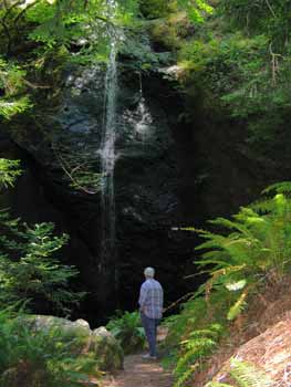
I was in my typical rage at not leaving as early as I thought we should but after a few miles my heart rate and blood pressure returned to normal and I started communicating with my loved one; Would you be up for a little walk? Are you thinking about going to the waterfall? Yep! Oh goodie. We left highway 20 just past Chamberlain Creek and drove the six or so miles of logging road up to the trail head, parked, then hiked down to the waterfall.
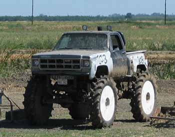
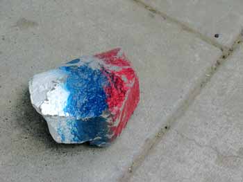
Beautiful! We checked out the redwood grove near the falls and picked up the trash left over from the Memorial Day visitors. Back up the trail to the Vanagon and on the road again. We have a month and a half of vacation and visit before us! A beautiful day and warming. 99.7 degrees when we stop for iced Mochas at Granzellas in Williams and 101.2 during the stop and go traffic through Yuba City/Marysville. Gas up. $2.21.9, the cheapest I have seen in a while. Regular in Fort Bragg the day before was $2.29.9. In the Central Valley I spot my first "goofy shit" of the trip. Last year during our summer break I decided to be sure to stop and photograph any oddity that caught my attention. Then, the theme was rampant red, white, and blue painted vehicles, tires and fences. Not so much of that this year, folks don't seem so hot for war anymore, but still... American ingenuity remains. Out of the Central Valley and up into the Sierras to Nevada City; I am hoping to find a campsite in the pines at a high enough elevation to be somewhat cooler. Highway 20 goes through National Forest lands and we start looking for wee side roads. We spot one, take it, and drive into the woods. Things are looking good and we find a nice spot. I get out and discover there is a motor home camped just around the bend. We back out and try a different way. Again we find a nice spot and when I get out I hear a small generator running. Sure enough, another motor home and this one not only has a generator running, they have a satellite dish! Must be watching TV! To heck with that! We return to the highway and continue on. I spot a rut off the other side of the highway and take it. Into the woods we go. Soon we enter a sunny area near the edge of a former clear-cut. Grassy, level, no neighbors.
Perfect! Lots of bird song; a few mosquitoes for my electronic, "tennis racket", bug zapper!! 65 degrees sleeping temperature during the night! June 3 After a leisurely get-up, breakfast, dish washing, book reading and some computer time checking the route via my DeLorme Topo USA software, we return to highway 20, continue to Reno via I-80, then turn north on 395. Piece of cake! Miles of boring freeway but eventually it narrows down to a two lane road and items of interest begin to show up.
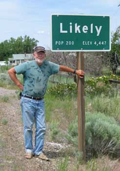
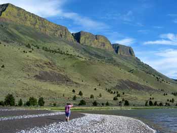
If I ever decide to move someplace...this place would be...er...likely Further on we see evidence of rail road track removal. It first caught my attention when I saw a guy with a road grader beside the highway and he obviously wasn't part of a highway crew; no Cal Trans markings, no amber flashing lights. I notice the former right-of-way is freshly graded! Miles and miles of it. One town had a wonderful old water tank beside the grade but the spout was missing. We reach Alturas and there is a big yard south of town with rail road ties stacked as high as warehouses and rows and rows of steel rails. All being salvaged. There are miles of rolling stock; grain cars and flat beds. We arrive at, and drive alongside, Goose lake, a huge lake that straddles the California and Oregon border We notice a sign that says, Historical Site, turn left. We do and drive down towards the lake and towards a huge saw dust burner. We wonder why there is a big saw dust burner when there are no trees. We get closer and come upon two boats beached high on the hillside beside a sign. Reading the sign we discover the boats were used to pull rafts of logs across the lake from the forested west side of the lake to the lumber mill on the east side. The sign said it took five hours for a boat to pull a raft of logs across!! The mill closed in 1959, the same year the mill closed in Greenwood/Elk. Most likely the railroad being salvaged came to this mill once upon a time. The end of an era. We start thinking about finding our place for the night. There is an item on my Topo USA map called Chandler State Park. When we arrive it turns out to be a "Day Use Only" picnic area. Oh well. Further on we try a section of former road but it is too close to the highway. Onward. We come out into more open valleys and ranch land, leaving the forested land behind. It looks like we are pretty well skunked. Then Lake Abert appears. Big lake. Almost as big as Goose lake. Along the east side of the lake is Abert ridge. The highway runs between the high bluff and the lake. After a while we find a wide pull-out on the lake side of the highway. We check it out and find a single gravel track going down towards the lake. We drive down a ways, then walk further to check it out. Perfect! Some flies and mosquitoes but not too bad, a warm wind keeps the bugs busy. Lots of shore birds. I fly my electric flying wing in the late afternoon a couple of times. We enjoy a big coyote sing in the early evening from across the lake. Geese honking all night long! The area very much reminds us of places we saw in Alaska near the Brooks Range!
June 4 Sunny morning, no wind, few bugs, lots of bird calls. Avocets. We enjoy a lazy morning, eventually pack, and head for Burns, Oregon. A roadside history sign informs us that Abert Ridge is a basalt fault scarp 2,500 feet tall! We are driving along the western edge of a fault block. Sort of small scale basin and range stuff. Lake Abert is a dead sea. Just a remnant of its former glory because, we are informed, the highway we are driving on is 250 feet below the original lake surface!! Amazing. The rest of the drive to Burns is pretty much straight forward and boring. We stop and make sandwiches at the city park in Burns. Across the way a group of Indians are having a barbeque and a celebration of some sort; I notice a big decorated sheet cake. The grandmother says her words, the group stands around listening with respect, then they dig in! Lunch over we shop for last minute groceries, ice, and gas. Soon we will be leaving the major highways, major towns, major box stores, malls and mayhem. Yippee! I call my sons on the cell phone. They will be heading for Moses Lake, Washington Saturday. We make plans to meet them Sunday afternoon or Monday. We change from highway 395 to 26 to 19. Each lowering of the highway numbers improves the scenery factor! John Day is a small interesting community but soon we enter...
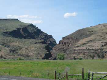
"Picture Gorge" where the John Day fossil bed National Monument is located. This crack in the mountain reveals a cross section, like a layer cake, of 17 lava flows during the past forty million years. This area has the most complete, continuous, fossil record in the world. It is now a National Monument. We stop at the brand new museum but it is getting close to their 4:30 PM closing time. We catch the end of a documentary and gawk at some at the displays, used the toilet, and hit the road. As I drive along I wonder what it must be like to work on some 30 million year old fossil and then go home and watch the evening news. The drive through the gorge, beside the river, is very nice but finding a place to camp is difficult; each little road down to the river rewards us with a No Camping sign. Onward. We see a private camp ground that is open to the traveler for ten bucks a night. We pulled in and looked around. It is a grassy sloping meadow with one shade tree and that tree already has a camper under it. We decide to press on. Just before Kimberly, Oregon we cross a bridge over the North Fork of the John Day River and spot, off to the left, a gravel road down to a boat launch. Some folks are hauling out their boat. We stop and talk to them and look around. We notice a small, dead-end lane to the left of the haul-out that looks perfect! We drive to the end and set up camp right beside the river on a pebbly beach. Lots of birds. A few bugs. I barbeque rib eye steak and make my world famous mashed potatoes. We enjoy a warm quiet night accompanied by the peaceful "white noise" from the river. June 5
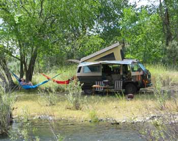
Do you know it starts getting light at 4:30 AM around here!! The further north we go the longer the days are. A few mosquitoes wake up and start looking around so I close the sliding door. We get up around 8:00. Correction. I get up around 8:00 and made coffee and get out our granola dishes, cereal, and milk. Lolli is laying in bed reading her book. Im thinking of spending today and another night here. Looking at the map I see we are 250 miles from Moses Lake. We should be able to rip that off tomorrow easily. I deploy the ShadyBoy awning and hang the hammocks! The river temperature is 68. Ambient air temperature is 80 at 9:18 AM. A few clouds but they are burning off. It could get too hot and we may decide to move on but we'll see. There is talk of walking into Kimberly, look around, see if we can buy some ice. We walk into Kimberly and visit the one store/Post Office/gas station then walk on down the road a ways and watch some guys fishing from rafts. A guided group. They started from the launch point by our camp and are heading to Spray, a distance of 15 river miles; 12 by road. We see one guy catch and release a fish. Walking back to the store we notice an older road above the current road. Since we are not wearing hiking shoes or, in Lollis case, long pants, we decide we will come back and explore that road later in the day. At the store we buy ice and a soda and some crackers. The lady at the store said she is closing at 12:30 because there is a big memorial barbeque for a local rancher who died of cancer at the age of 58. She invites us to attend but we decline. Back at camp it is a perfect lazy afternoon for reading our books. Then the weather gets weird and it clouds up. The clouds keep the day from getting too hot but it starts to sprinkle! Then the sun comes back out and it starts getting hot but then it clouds up and sprinkles! Strange weather to us coastal folks. Beautiful cloud formations though. Reminds us of summertime camping in the mountains of New Mexico; daily afternoon rain showers. Birds. Lots of birds. I get out the bird book Suzanne gave me and start looking them up. Red wing Blackbirds, Morning Doves, sparrows and starlings, no problem. And, what are those beside the river? I check the book, ...Spotted Sandpipers. A Golden Eagle flaps by with a small bird chasing it. The eagle is working hard until it gets over to the canyon wall, catches some lift, and begins soaring in circles higher and higher, leaving the little bird far behind. It finally gets high enough to slip out of the uplift and head for the next canyon. Beautiful! We walk back into Kimberly and hike the old road. It is shored up with hand placed rocks in places. It had to be the original wagon road, once upon a time. We enjoy a "Vegetable Medley for snackage then barbeque chicken for dinner to go with my world famous mashed potatoes. I decide to take down the ShadyBoy and the hammocks. Tomorrow will be a travel day. June 6 Daybreak at 4:23 AM!! One solitary mosquito with nine lives bothering us. I get up at 7:00 AM, write this, and have my coffee. Partially cloudy. Im thinking of plugging in my solar panel but there is no direct sun. The volt meter shows 12.5 volts. Probably enough but I hope to get a jump on the day and be rolling by 8:00~8:30. Well see. 8:30 AM and we are packed and on the road. A nice drive along the John Day River to Spray but then the road leaves the river to go to Fossil. Up and up and up into the pines... Then down into miles of ranch lands; wheat country...
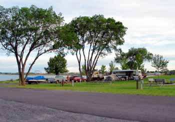
home of the Microsoft screensaver! A few dips into canyons, back out, and finally the Mighty Columbia. We stop for gas and I just have to take a picture of their door stop!
Onward. Drive drive drive and around 3:00 PM we arrive at Moses Lake, Washington. I am amazed at how much housing and industry has spread out in the Tri Cities area and Moses Lake; spread out for miles. I start becoming concerned as we drive further and further into the strip malls, box stores, and housing clusters on our way to Ross and Jeffs campsite location. We turn off onto a street through a development and arrive at the park. Holy shit!, hundreds of cars and boats and some camp trailers. They are all clustered up at one end of the park. We notice Jeffs truck and boat at the other end. I call Ross on the cell phone. He says he can see us and to continue straight ahead. Then we see his trailer on a bluff overlooking the lake. Jeff and Trinnas tent is set up beside it but man o man is the wind blowing! A warm wind but still very windy with black clouds coming from the west. Not looking good. They are all pretty bummed because the wind has been blowing since they arrived. We visit a bit and get the lay of the land. Ross tells me all the people at the other end of the park are involved in a fishing derby and will be going home soon. The plan is to move the whole operation down to a lower site closer to the lake and, hopefully, into an area with less wind. We all pitch in and accomplish the move After we get everything pretty much set back up...the wind dies!!
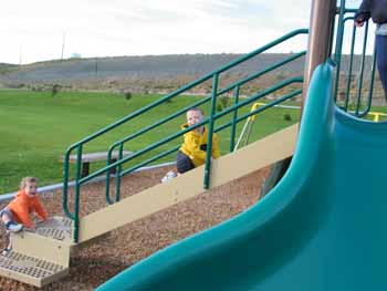
There is a slide and swing set near camp and Kian and Lane have a great time with Grandma Lolli up on top loading them into the chute and Kerry or Trinna catching them as they slide down. Both boys walking good, fighting over toys, mouths full of teeth, Lane still going "broom broom" when he sees anything airplane related. Jeff, Ross and I go flying! I fly my wing. Jeff flies his electric Tiny X and electric Edge 540. We go down to the lake and Ross flies his Heckler on floats, Jeff, his DuroPlane on floats. The wind is "on shore" and landing tricky but Ross and Jeff pulled it off. We have a nice dinner of Trinnas "soup"; hamburger, corn, beans and tomatoes, with cheese and sour cream on top. Margaritas on the side and we are happy campers. June 7, 2004
The camp host has us tighten up our operation a bit. Move some cars and the boat to the guest parking area and move our Vanagon around to the back side of Rosss trailer. Everyone else has gone home from the weekend fishing derby, the campground is finally empty. Today the sun is out, the clouds are few, and the wind is just a breeze. The big plan is to visit the Super Wally! Ross and Jeff were there the other day and Jeff bought a nice LED flashlight. It works good and I want one. Trinna and Kerry are going to a store to buy steaks for tonight's barbee.
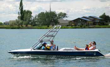
Jeff launches his boat but we don't do much with it.
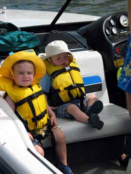
Both grandsons are ready though!
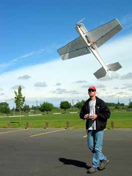
Jeff demonstrates his electric powered Edge 540.
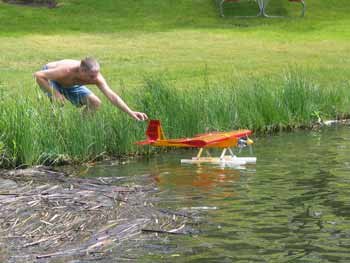
Ross flies his Heckler. Steak with potatoes baked in aluminum foil for dinner, mmm, good! June 8 Some rain during the night and not looking good this morning. A grounds keeper starts mowing around our camp at 6:00 AM. Kerry gets up and gave him "What For"!! You go girl!! Also some folks arrived at 11:00 last night and parked their boat about two feet from our Vanagon. Lolli thought they were going to hit us! What with close neighbors and crappy weather Lolli and I decide to head for Seattle. Ross and Kerry and Jeff and Trinna are talking of going to Pullman so Kerry and Trinna can revisit the college campus, "Wazoo". We say our "byes" and hit the road. We stop and visit a good friend in Wenatchee. We are on the road again by 4:00 PM and according to my Topo Map we can be in Seattle by 7:00 PM. We decide to go for it and take Stevens Pass. Over the top, around 4,200 feet, and down into pouring rain through Startup, Sultan, and Monroe, Washington but, unbelievably, once we reach the flats east of Everett the sun comes out and it is 82 degrees! We arrive at Lolli's moms house, shower, and I check my e-mail, 108 waiting! A wee snack and time for bed-e-bye. June 9 I check my "VW Info" section in my laptop and find Schaffers motors; highly recommended by the WetWesties as a place to get Vanagon parts. I zip up old Hwy 99 to their yard and buy a lower radiator grill to replaced the one I lost to a deer, and, four small hubcaps. June 10 Crappy weather. The "visit" portion of our vacation has begun. We will be heading for Denver, Colorado when vacation resumes; sometime towards the end of this month.
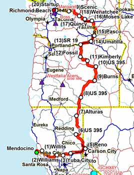
Here is our route so far. 1,258 miles! $141.00 worth of gas.
|
On to part two. The Visit part of Vacation!